15 September, 2010

Interview With Liz Jones

Liz Jones has been climbing with Mountain Tracks for the last 3 summers. She specialises in hard Alpine routes, and is equally happy on rock, ice or mixed ground. Liz steers away from the big snowy routes and peaks, instead choosing technical climbs of high difficulty.
Liz lives in Yate, Gloucestershire and to prepare for Alpine climbs she trains in North Wales and the Brecon Beacons. If you live anywhere close to Yate, you may have been served by Liz in the local Tesco where she works.


MD:What inspired you to begin alpine climbing?

LJ: My first walking trip to Chamonix in 2000 inspired me to want to climb Mont Blanc, so I returned the following year with my then boyfriend and climbed with a guide. We did several easy classic routes which built up to an ascent of the Cherie Couloir on the last day. The boyfriend hated it and never returned but I was bitten by the bug and never looked back. I still haven't climbed Mont Blanc though!!

MD:How do you prepare for your Alpine climbing? What advice would you give to people before their climbing trip begins?

LJ: My preparation for a climbing trip. Mmmm, not enough!! I am lucky to possess a pretty good level of basic fitness from just general day to day walking the dog and looking after my horses. I supplement this with long hill walks and running. I try to make sure that I'm as fit as I can be, even if this means that I have to sacrifice climbing days for a good long walk in the hills. I find that I can get climbing fit indoors if needs be. In fact, I think that you can get a lot stronger by climbing indoors rather than messing around on easy rock routes. However, I try to make sure I get plenty done outside on long multi-pitch routes to get the head around the whole exposure thing, as the big routes in the Alps are on a whole different level to anything home here.

My advice to anyone coming out to the Alps for an alpine climbing holiday, whether to climb rock or big peaks, is to be as fit as you can possibly be. I also would advise getting to know which foods you like when you are being pushed to your physical limit. I find it really hard to eat on routes especially at altitude. I know from experience that I like Twix and saucisson! It's definitely worth getting as slick as possible with all your rope work too, it saves a lot of time. You can end up in some spectacular positions and the pressure is on to get everything right.


MD:What do your work colleagues think about your exploits?

LJ: My job couldn't be further removed from the mountain environment!! I work for Tesco as a checkout girl!! My customers have no idea that whilst scanning their groceries, my brain is working overtime planning the next big route in the Alps. My managers don't actually know what I do on my holidays, best not to tell them!! Some people there think I'm mad, as they are more interested in OK magazine and Eastenders, but a lot of my colleagues are very interested even if they don't actually understand exactly what I get up to.


MD:Describe a magical moment you have experienced when alpine climbing.

LJ: That is a difficult question as there have been so many. But if I had to choose one, then it would be sitting below the North face of the Tour Ronde, waiting for dawn to break. It was the first time I had experienced the alpine night sky properly, as we just sat and looked up, rather than walking head down. The sunrise was as perfect as the route. And we had that all to ourselves as well, which is rare indeed.


MD:How do you feel about the dangers associated with alpine climbing?

LJ:I have yet to experience a thunderstorm up close and personal, but hopefully by good planning, speed, and close attention to the weather forecast, it's something that I can watch from the valley balcony. There is always going to be danger in the mountains, and you need to be aware but not let it become an overriding thought, or you cannot get anything done up there. When the worry overrides the enjoyment, then it's time to give up.

MD:You tend to steer away from the big Snowy peaks, in favour of more technical routes, why is this?

LJ:I think that I'll leave those for the time in the future when I have worn out my fingers on the rock!! I do like a good view from a summit though, but I like to feel that I've had to work for that summit a little bit harder, hence the reason I like more technical routes.

MD:Which routes do you aspire to climb?

LJ:Routes that I would love to climb, well, there is an endless list!! But if I had to pick five, then they would be as follows. Cassin route on the Piz Badile, Freney Pillar, Walker Spur, Diable Ridge and the Ginat Route on Le Droites.

MD:What’s next for Liz Jones?


LJ:I would like to attempt some long ice routes in the Alps this winter. I'm also going to get as many days in the hills as possible as I am going to start working towards my International Mountain Leader qualification. I have made plans to spend three months in Chamonix next summer, with the intention of getting plenty of days trail walking for my logbook. This will of course mean that I'll be getting very fit, and I intend to put this to good use in the higher mountains as well, and will fit in as much climbing as my fingertips will allow!!

09 September, 2010

How difficult is the Matterhorn?


The Matterhorn is the most easily recognised peak in the world. Many climbers and walkers aspire to climb it. But how difficult is the Matterhorn? This is a question we are asked frequently. The fact is, looking from Zermatt, the peak looks nothing short of terrifying! Compared to most alpine peaks it looks impossibly steep and uncompromising. But on the other hand it is a popular mountain which is climbed on a daily basis by people without vast amounts of experience. The route is both complex and loose, so it is a necessity that the leader knows the mountain well. We would never advise attempting the peak without using a qualified guide.


The most important attributes for the ascent of the Matterhorn are fitness, determination and 'sure footedness'. Typically the summit day is between 9-12 hours, that's pretty much non-stop without long breaks. There is an old joke regarding the lack of rests. 'A British climber was tired on the approach to the Solvay hut (half way bivouac refuge). So he says to his Zermatt guide "please can we rest and have a drink", to which the Zermatt guide replies "yes, at the Solvay Hut". When they get to the Solvay hut the guide does not stop. The English climber, says "I thought we could stop for a rest at the Solvay hut" to which the Guide replies "yes that's right, on the way down"!


Sure-footedness is of prime importance on the Matterhorn. This is different to climbing ability. I have guided good climbers who are not sure footed and non-climbers who are surefooted! This simply means the ability to be agile and secure when scrambling on rock, ice and snow. This ability can be learned by practising scrambling and easy climbing. The climbing on the Matterhorn is not so hard, but it is exposed. That means it is important not to take a fall.


When climbed via the Hornli ridge, the Matterhorn ascent is graded AD with a vertical height gain of 1300m (from the Hornli refuge). The climbing is never more difficult than the British grade 'Moderate'. The climbing is mainly on rock, however the upper section is usually snow and ice. The most difficult sections have fixed ropes.


There is no doubt that climbing the Matterhorn is an intensly satisfying experience, and one which will stay with you for a lifetime. Plus, everybody has heard of the Matterhorn so it is instantly recognised by family and friends.

At Mountain Tracks we offer Matterhorn courses from July - September. The courses are 6 days in length and include 4 days of training & acclimatization climbs around Zermatt or Saas Grund prior to the 2 day Matterhorn ascent. Participants should have some alpine mountaineering experience before the Matterhorn week, although being an expert climber is not a prerequisite.

These pictures were all taken from a recent trip with Don McGill and David Rowlands. Both summited the Matterhorn on Friday, 3rd September 2010.

If you'd like to climb the Matterhorn, take the first step by contacting our office on +44 20 8123 2978 or by emailing Chris at chris@mountaintracks.co.uk

08 September, 2010

Up Close and Personal with an Icy Time Bomb

I have just made a successful Mont Blanc with a Mountain Tracks team of 5. On the way up to the TĂȘte Rouse hut we passed all the engineering works for the draining of the subterranean glacial pool. There are thousands of gallons of water trapped in a large pool below the TĂȘte Rouse glacier. If the pool bursts it will send a raging torrent down towards St Gervais. It's not as if it hasn't happened before. Last time this occurred in the 1800’s it killed a few hundred people. Now it's predicted to affect more than 9000 inhabitants should the worst happen.
I took some shots of the instruments used as an early warning.

There is radio transmitter station connected to a cable running across the gully below the main glacier bowl. This is supposed to detect increases in water flow rate. I'm no hydrology engineer but it seems to me if you live in St Gervais you have about 10 minutes to start running up hill!
To drain the lake French engineers have been drilling and digging into the glacier and extracting the water using large pumps. This is lengthy process hampered by the recent poor weather in the Alps. I should imagine they are worried winter will come early and make working at 3200m impossible.
We had a snippet of these conditions last week where the temperatures at that altitude fell to -15degrees with strong winds and snow. Working in these conditions is impossible as all metal equipment starts to freeze. I'm pretty sure the engineers aren’t too happy working in these conditions either.
If the subterranean lake isn't drained in the next two months temperatures will hamper further progress leaving the problem unresolved until the spring. It is already having an effect on ascents of Mont Blanc and walking the Tour du Mont Blanc as certain paths are closed and the TMB train stops an hour short of the top. Due to this Mountain Tracks have been running some of our Mont Blanc ascents from the Aiguille du Midi as it’s a shorter return journey.


Olly Allen

Mountain Tracks Guide

15 August, 2010

Gulmarg Skiing Video


Adam has just finished putting together a new video using my footage from Gulmarg 2010

This should get you all fired up for the coming winter. There aren't many places where you can order a curry on the slopes every day! I spent over 3 weeks out there last winter and loved every minute (appart from Matt's snoring)!

Patience and a horizontal attitude helps to smooth Kashmiri relations. If you want genuine adventure skiing look no further.

See you there this season,

Olly


MPORA Action Sports >>

05 August, 2010

Traverse of Pointes Lachenal

Klemen enjoys a day out on the Traverse of the Pointes Lachenal at the foot of Mt Blanc du Tacul above Chamonix with Hilde, Cathrine and Elisabeth.

The traverse is a good introduction to mixed terrain alpine climbing and an excellent training & acclimatization day for further 4000m climbs.


Want to try this? Contact Susie susie@mountaintracks.co.uk

19 July, 2010

Summit successes all round so far this summer

Klemen traversing the summit of the Matterhorn

The Alps have been blessed with amazing weather since the beginning of July and we have had almost unbroken sunshine for a few weeks. The temperatures have hit a scorching 35 degrees in places and it has been nice to escape up the mountain to cooler temperatures.

Our guides have been out leading trips across the Alps and everyone has enjoyed excellent climbing with ground conditions. Olly guided a group around the Swiss Valais and climbed some of the classic 4000m peaks in the area. Klemen Gricar, who many of you will know from the winter has been busy guiding in Chamonix and Zermatt for us. We have had a group successfully summit the Matterhorn recently, well done to Mark and Andrew for their achievements.

Mark, Andrew and Ross (guide) on the summit of the Matterhorn

Klemen has also guided Hayden and Clifford to summit four 4000m peaks above Zermatt, these were Roccia Nera, East Twin, West Twin and the Central summit of the Breithorn. They also completed ascents of Castor and Pollux to add to their tally; congratulations to them both.

Hayden and Clifford

Matthew Betts and his friends have just finished their trip to Chamonix and the Italian and Swiss Alps. After some warm up days in Chamonix they headed to Zermatt to meet Klemen for the Spaghetti Tour, which is an amazing circuit around the Matterhorn and Monte Rosa area. A report in this morning from Klemen says they climbed eleven 4000m peaks in 6 days, pretty good going.

Matthew and Friends atop the Breithorn

Olly has just set of on an ascent of the Eiger and Matt is away in Saas Grund with Karen and John for a week of climbing. We have a Haute Route Trek starting on Saturday and places still available on another from the 11th – 20th September as well as a Bernese Oberland Trek from the 4th – 11th September if you still want to get away into the mountains this summer.

View from the summit of the Dent du Geant down the Mer du Glace

We have also had some busy weeks in and around Chamonix, the Tour de France once again passed close by; with a stage finish in Morzine/Avoriaz. Lots of people headed across to watch and ride the climb before the riders passed though. Being a Lance Armstrong fan it was sad to see his chances of a podium victory disappear that day in a series of crashes during the day; but it will be interesting to see how Alberto Contador and Andy Schleck fight it out for the win.

We have also had the World Climbing Championships take place in Chamonix last weekend, watching the men’s and women’s finals of the difficulty and speed competitions on Tuesday night was amazing. The huge crowds erupted when French girl Charlotte Durif won the women’s difficulty. Ramon Julian Puigblanque from Spain won the men’s difficulty and afterword’s the crowds enjoyed the firework display to mark the Bastille Day celebrations.

Last Wednesday saw Glen Plake, now a Chamonix resident, and all time ski hero give a talk at the Cinema prior to a showing of the famous, cult movie Blizzard of AHhhhhhh’s. Mr. Plake was then one of the judges for the Nissan Outdoor Games held in Chamonix all of last week. 5 teams put together a short movie showcasing climbing, kayaking, paragliding, speedflying, basejumping and mountain biking. Some outrageous stunts were pulled including basejumping from paragliders, mountain biking off the ski jump in Chamonix and soloing some crazy climbing routs. Team Argon won the competition with their film, you can view all the films at the Outdoor Games Website.

06 July, 2010

EVEREST 2010


This spring I was invited by expedition organisers Adventure Peaks to co-lead an expedition to the North Side of Everest. Much as I enjoy the spring ski touring season with Mountain Tracks I jumped at the chance. I had always wanted to go to Everest and for the same reason as most: that it is the worlds highest mountain. Also the chance to go via the North side was appealing as it is less commercialised and necessitates an interesting journey across the Tibetan Plateau.
We had a grand total of 24 people in our group. 17 attempting Everest, 5 going to the North Col plus myself and Stu Peacock, the two leaders. It was a varied group: 23 men and one woman. Ages from 20 through to 48. Most of the team were professional people taking a career break who had always fancied climbing Everest, some were sponsored. Ex-England rugby star Josh Lewsey had significant media coverage, newspapers ringing him for updates on a daily basis. The group ‘gelled’ very well, this was helped by the strong sense of mission and the combined commitment to attack the mountain.


Journey

After initial preparations in Kathmandu the first week of the expedition was spent acclimatising on the Tibetan Plateau. Good acclimatisation is the key to Everest, and the process is gradual and structured. The Base Camp is at 5200m, which is 400m higher than the summit of Mont Blanc. It takes a minimum of a week for the body to be able to withstand the altitude at base camp and 2-3 weeks for the body to become used to it. The journey to base camp has become progressively easier over the years as roads have improved. It is now possible to reach base camp by vehicle in a single (albeit long) day from Kathmandu. Whatever your views on the Chinese presence in Tibet, one thing is for certain, the Chinese have improved the infrastructure hugely and throughout the province there are good roads, electricity and phone coverage. However Tibet is still a very harsh place to live. The climate is dry as a desert and constantly windy. The temperatures swing violently throughout the day with hot days, and freezing nights. The Tibetans are some of the world’s poorest people and most make a living from primitive agriculture.

Base Camp

Base camp is also a bleak place. It was situated at the snout of the Rongbuk Glacier with the North face of Everest always towering above. There is no vegetation, just huge piles of Moraine and rubble. The wind here is constant and takes some getting used to. The day time temperature was typically around 5-10 degrees, and the nights -5 to -10 .As the spring progressed it did get slightly warmer, but most of the time it was necessary to wear a down jacket. We had 2 large mess tents for meals and communal space, plus every member has there own personal tent. All meals are prepared by the cooking staff. For entertainment we had two large TV's with a good selection of DVDs.


Advance Base Camp

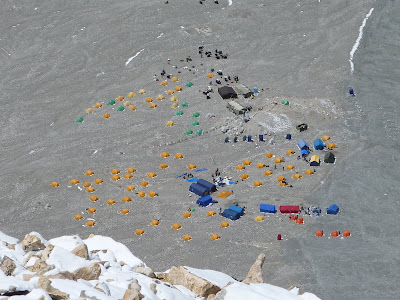
Following the glacier up from base camp, the next camp is Advanced Base Camp or 'ABC' which is at 6400m and 12 miles from BC. The trail follows the moraines of the East Rongbuk glacier. Initially we walked this section in two stages, but thereafter in a single day. This was a stern test of fitness for everybody. We found the effects of altitude really kicked in at 6000m. The equipment was brought to ABC by yaks. At 6400m, advanced base camp is too high to be able to stay strong and rest properly so during the trip we made regular descents down to base camp for periods of recuperation.


ABC is located on the lateral moraine of the East Rongbuk Glacier below the North Col. The site extends for several hundred yards up and down the moraine, and various expeditions' camps are scattered along the terrain. It's rocky and broken ground, requiring a lot of work to create tent sites. From the camp you look directly up the North Col, but what really dominates the view from ABC is the Northeast shoulder of Everest with its famous Pinnacles. In the words of expedition member Heather Geluk:

“The smell of yak dung on what has been dubbed, “The Moraine Superhighway”, sent my stomach reeling. A distance that should have taken about ten minutes to cover ended up taking an hour and left me gasping for breath. Having said that, the views with every “breathing stop” were spectacular - a bright blue sky provided the backdrop for giant towers of ice on either side of the moraine as well as Everest which loomed seemingly omnipresent to the right of the rocky path. It was an awe-inspiring sight.

Step - breathe - step - breathe - step - breathe… I could feel my heart pounding in my chest. The altitude was 6100m and we still had another 165m to climb - it didn’t seem like much but the throbbing pain in my temple indicated that it would not be a straightforward altitude gain. The rocky moraine crunched under my feet as yet another herd of yaks passed.

“Namaste!” shouted the weather-beaten yak herder. The yaks lumbered past, with their huge horns and shiny wet noses. These gentle giants are clearly made for these conditions ambling along the rocky path with their yellow hoofs. These particular yaks were coming back down from ABC and had been decorated with prayer flags and amulets. The bells around their necks seemed to clang steadily in line with their steps. The smell of a passing yak herd is quite overpowering - the best description I can come up with is a milky sweet smell mixed with wet woolly socks….

The old weather-beaten leathery-skinned yak herder walking up the moraine in the equivalent of flip-flops looked at me in silent amusement as I tried to put one foot in front of the other.”


North Col

The next stage is the ascent to the ‘North Col’. This famous place is pretty much exactly 7000m and and is the saddle between Everest and neighbouring Changtse (7500m). To get to the North Col requires a steep ascent on snow and ice using crampons, ice axe and fixed ropes. This ascent is where the real climbing starts. After our first inspection of the route to the North Col, no less than 4 members of the expedition decided to throw in the towel and head home! The reason for this was that this section brought into focus the potential severity and commitment necessary on Everest. These members returned to base camp and ordered transport back to Kathmandu. It was sad to see these guys leave the team, but it is very important that everyone on the mountain is committed to the project.


Camp 4 and 5

The route from the North Col camp up to Camp V starts with several thousand feet of moderately steep snow and ice up the North Ridge. It is usually battered by exceptional crosswinds from west to east and it is not unusual for climbers to be knocked off their feet here. At 7500m the terrain changes from snow to rock. There are fixed ropes on this entire route from the North Col to Camp V.
At camp V (7700m) we began using oxygen, this had been pre-deposited at the camp by our Sherpa team. It was the first time I had used oxygen and at a moderate flow rate, I was surprised how little it helped! Upward progress is still extremely tiring. I found that the use of oxygen gives you 1000m of benefit. So climbing at 8000 becomes like 7000 without oxygen and climbing at 8500 becomes like 7500m without oxygen. Like Camp V, Camp VI occupies several different sites starting at about 8100m—where the 1975 Chinese expedition established Camp VI—and then extending up to where our camp was established, at about 8300m. This camp consists of very small sites for tiny high-altitude tents. The sites are dug out of the rock and dirt built up around the old shale debris. The camp is located just below the Yellow Band. From here, we can look up to the Northeast Ridge and see the First and Second steps up to the summit and then look down into Tibet. The view from Camp VI is very impressive, but we would expect that from the worlds highest campground!


The Summit Day

The summit day begins at 10pm (yes pm). At 8300m everything takes a long time. Melting water for drinks is a long process, putting on boots and crampons takes 10 times as long as it normally would. So we eventually left the tents at around 11.30pm. The first section is a long ramp through the yellow band which after 3 hours deposits us on top of the North Ridge and for the first time a view down to Nepal. The first serious obstacle is the ‘first step’ which is a short but awkward climb.

The second difficult section is the aptly called ‘second step’ The 1975 Chinese expedition placed a ladder on this pitch which is now commonly used for the ascent. While the ladder is only 15 feet high, it is dead vertical and tends to move while climbers ascend it. From the top rung of the ladder, a tricky mantle move onto a ledge leads to easier terrain below the top of the Second Step and close to the crest of the Northeast Ridge. At this point the exposure is incredible, with the entire North face at your feet, literally 3500m of exposure.

The Summit Pyramid remains as the final obstacle. The summit snowfield occupying the northern aspect of the final pyramid is steep and crowned by a bastion of rock, the summit tower, which is usually bypassed on the right along the uppermost part of the North Face. A ramp involving three rock steps leads back left onto the summit ridge. The summit pyramid takes at least an hour to ascend. An undulating snow crest some 500 feet in horizontal distance, the summit ridge leads up to the highest point of Everest. The ridge is not steep, but is exposed, with a 3500m foot-drop on either side. Enormous cornices overhang the Kangshung Face (East Face) on the left, so climbers are forced to stay on the northern side of the final ridge.
5 members plus a number of Sherpas summited on Everest and the whole team returned safely. A number of members who had not summited wanted a second attempt but this was not possible due to the early arrival of the monsoon.


Reflections

This time I didn’t summit on Everest, I chose to turn around at around 8700m. I had developed a chest infection early in the trip which caused me a lot of problems high up on the mountain. Admittedly this was a disappointment for me; however as a guide it was not my place to take personal risks. It was important that I had enough fuel in the tank to not only get myself off the mountain but also to assist others. But in a general sense I found the trip interesting, exciting and rewarding. I certainly felt the ‘lure of Everest’. Although most of the time the mountain offers discomfort and often tedium there is something addictive about the place. In the words of Cyan Singe on the first Indian expedition:

The Lure of Everest, the call of the high mountains, the
quest of the almost unattainable, what is it that draws, generation
after generation, all mountaineers to this brave and dangerous
adventure? Great mountaineers have sought an answer to this
question and found no adequate one. All they could say was that
they felt this call and tried to answer it. Is it some part of the
eternal quest of man, some overflow of that vital energy which
has kept humanity going from age to age in its attempt always
to reach some higher peak of human endeavour.

I look forward to returning to Everest.

If you are interested in climbing Everest, please register your interest with Mountain Tracks by contacting Chris on 020 8123 2978 or emailing him at chris@mountaintracks.co.uk